1006 Morton Street
Baltimore, MD 21201
410.576.9131 | RW1haWw=
March 23 2008
Google Earth for Air Emissions
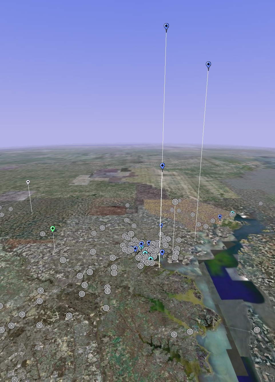
(above) Air Polluters in Baltimore - Can you guess where the Constellation Energy plants are?
Now along with mountain ranges, roads, restaurants and tourist destinations, you can search for air pollution production levels around the United States! That is right, the EPA has created an dataset for Google Earth which allows you to map the six principal air pollutants by producer in a given area. Facilities producing more of a certain air pollutant appear as taller bars on the map which creates a topography of pollution. These air pollutants include:
- carbon monoxide
- lead
- nitrogen dioxide
- ozone
- particulate matter (also known as particle pollution)
- sulfur dioxide
It is great to see the federal government use such advanced applications to share information with the American public. This type of transparency within government is essential for building an informed public and encouraging the political will to affect change. I think once people see the pollution being generated, or not being generated, by facilities in their area, that they will demand solutions.
To view a map please download Google Earth and visit the EPA website to download the Google Earth File for your specific area.
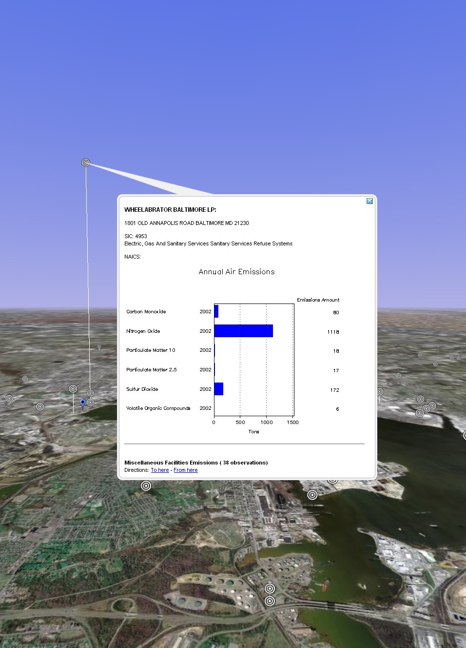
(above) An example of air pollutant data for each source.
Recent Posts
Reimagining Harborplace to Create Space for Both Private Development and Expanded Public Space » Lawyer's Mall Reconstruction Progress » Confronting the Conventions of Customary Practice » Reconceived Facades: New Roles for Old Buildings » Ivy Bookshop Opens for Business! »
Categories
Yellow Balloon Baltimore » Products + Technology » Industry + Practice » Other » Architecture »
Links
Organizations
- USGBC Baltimore Regional Chapter »
- AIA - American Institute of Architects »
- USGBC »
- The Walters Art Museum »
- Green-e »
- Center for Building Performance and Diagnostics (CMU) »
- Green Globes »
- Prefab Lab (UT) »
- Center for Sustainable Development (UT) »
- Architecture 2030 »
- Bioneers »
- Street Films »
- FreeCycle »
- Chesapeake Bay Foundation »
- Archinect »
- BD Online - The Architects Website »
- National Wildlife Foundation »
- Natural Resources Defense Council »
- Overbrook Foundation »
- Merck Family Foundation »
- Ecology Center »
- New Building Institute »
- Neighborhood Design Center »
- The Leonardo Academy »
- ZigerSnead Architects LLP »
- The Rocky Mountain Institute »
- Urban Habitats »
- ACORE - American Council on Renewable Energy »
- Parks and People Foundation of Baltimore »
- Open Society Institute of Baltimore »
- Natural Capital Institute »
- Passive House US »
- Svanen Miljomark »
- Green Restaurant Association »
- Rocky Mountain Institute »
- Green Exhibits »
- Green Roundtable »
- John Elkington - SustainAbility »
- SustainAbility »
- Building America »
- Endangered Species Program - Fish and Wildlife Service »
- Congress for the New Urbanism »
- Urban Land Institute »
- Cool Roof Rating Council »
- Montgomery County (MD) Public Schools Green Building Program »
- National Institute of Standards and Technology Software »
- Scientific Certification Systems »
- Community Greens »
- CBECS »
- CASE - Center for Architecture Science and Ecology »
Interesting Sites
- The Ecologist »
- Treehugger »
- Grist »
- WIRED »
- Planet Architecture »
- MiljoBloggAktuellt - Environmental News Blog (Swedish »
- Sustainable Design Update »
- Eikongraphia »
- World Architecture News »
- The Cool Hunter »
- Design Center »
- ZEDfactory »
- Architen Landrell Associates Ltd. »
- Environmental Graffiti »
- businessGreen »
- Best Green Blogs Directory »
- Groovy Green »
- EcoGeek »
- Urban Ecology »
- Locus Architecture »
- Urbanite »
- A Daily Dose of Architecture »
- Adaptive Reuse »
- Audacious Ideas »
- Big Green Me »
- NOTCOT »
- Sustainable Baltimore »
- Thoughts on Global Warming »
- Green Maven »
- WorldChanging »
- Go For Change »
- Building Green »
- Home Energy Magazine »
- Home Energy Blog »
- FEMA Map Service- Federal Emergency Management Association »
- Architectural Graphic Standards »
- E-Wire »
- Post Carbon Cities »
- Alt Dot Energy »
- Whole Building Design Guide »
- B'more Green »
- EJP: Environmental Justice Partnership »
- Baltidome »
- OneOffMag »